| Data/Hora: 28 abr 2024 16:49 |
|
Os Horários são TMG |
|
|
Página 1 de 1 |
[ 3 mensagens ] |
| Versão para impressão | Tópico anterior | Próximo Tópico |
OSM
| Autor | Mensagem |
|---|---|
|
Aventureiro  Registado: 21 mai 2010 20:58 Mensagens: 164 Localização: Loulé-Santarem- Algures em África |
http://www.openstreetmap.org/ 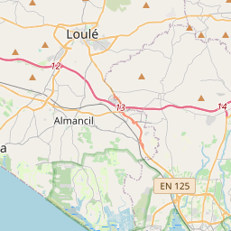 Este post tem algum tempo e é original no Nomads http://www.nomadstrail.net/site/index.p ... pic=5983.0 OSM -Construído pelos utilizadores para os utilizadores, e gratuito. Os mapas são totalmente editáveis, existem varias ferramentas de edição para os mapas: http://wiki.openstreetmap.org/wiki/Editing (mais informações aqui) E possível transferir mapas para Garmin http://wiki.openstreetmap.org/wiki/OSM_Map_On_Garmin (mais informações aqui) E possível transferir (construir) mapas rotáveis para Garmin http://wiki.openstreetmap.org/wiki/Routable_garmin_maps Para quem ficou interessado http://wiki.openstreetmap.org/wiki/Beginners'_Guide processo basico: 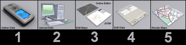 Informação detalhada sobre equipamentos GPS http://wiki.openstreetmap.org/wiki/GPS_Reviews Comparação entre mapas Google e OSM - http://tools.geofabrik.de/mc/index.html OSM em portugal A comunidade portuguesa é incipiente, apesar da muita informação já introduzida, muitas das estradas camarárias e locais não estão disponíveis. Informações sobre o OSM OpenStreetMap (OSM) é um projecto colaborativo para criar um mapa livre e editável do mundo, inspirado por sites como aWikipedia, o mapa construído pelos utilizadores para os utilizadores, hoje existe muito pouca gente (inter nauta) que não use a wikipedia, provavelmente num futuro próximo, será o mesmo com o OSM, só terá de juntar a massa critica (utilizadores / editores ) que permita uma fiabilidade aceitável. Tem também sido disponibilizada alguma informação de agências governamentais, dados libertados sob licenças apropriadas. Muitos destes dados provém dos Estados Unidos da América onde é exigido ao governo federal que facilite tais dados ao público. -Imagens de satélite Landsat 7 -Prototype Global Shorelines (PGS) -Sistema TIGER dos EUA Algumas agencias como a Ordnance Survey estão a repensar a sua estrutura (actualmente vendem dados), por forma a libertar dados. Existindo também dados provenientes de empresas comercias. Cump. _________________ "Do not go where the path may lead ; go instead where there is no path and leave a trail." _R.Waldo |
| 07 out 2010 11:07 |
 
|
|
Aventureiro Registado: 21 mai 2010 20:58 Mensagens: 164 Localização: Loulé-Santarem- Algures em África |
Programas para utilização em off-road
AFTrack - 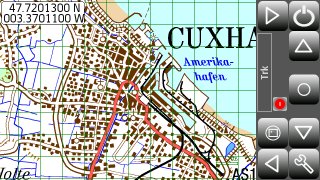 http://www.afischer-online.de/sos/AFTrack/index.html -Six views to the GPS data - position, goto, track summary, map, altitude profile, satellite -Tracking the current way -Export tracks (PCX, IGC, KML) -Import routes from routes or tracks (PCX, GPX, KML, OVL) -Degree or UTM format -Edit position in selected output format -Import JPG, GIF, PNG, BMP, TIFF, GeoTiff or BSB as map. -Calibrate maps with various types -Automatic calibration from different cal file formats -Automatic map selection from the map storage -Waypoint group to organize the waypoints -Save current position as waypoint -GoTo a waypoint -Import waypoints (PCX, Geocache LOC, GPX) -Export waypoints (PCX, KML) -Using extra text files for waypoint description (e.g. details of a geocache, groundspeak:long_description is supported) -Make route from a track -Makes way points to area -Reverse routes -Alarm on reached POIs, anchor alarm -GPRS position sending -SMS position sending -SMS position receiving -Reset GPS from SIRF to NMEA mode -Automatic reconnection to GPS if connection lost -Filter the altitude and speed values with a Kalman filter -Logging the NMEA sentences -Long time tracking -Support for GLONASS satellites (extern gps only) Em teste a Versão para 5th Gen. (1.03) mais tarde deixarei aqui resultados Sports Tracker Também usa mapas OSM, com uma função um pouco diferente, mais um computador pessoal de desporto. mas com funções interessantes para as verdascas.  http://www.sports-tracker.com (actualmente em teste ) _________________ "Do not go where the path may lead ; go instead where there is no path and leave a trail." _R.Waldo |
| 17 out 2010 08:29 |
|
|
Aventureiro  Registado: 18 mai 2009 10:36 Mensagens: 221 Localização: Faro |
Parece muito interessante.
Obrigado!  _________________ Rui Puga KTM 990Adv Faro |
| 04 jan 2011 11:05 |
|
|
|
Página 1 de 1 |
[ 3 mensagens ] |
|
Os Horários são TMG |
Quem está ligado: |
Utilizador a ver este Fórum: Nenhum utilizador registado e 1 visitante |
| Criar Tópicos: Proibido Responder Tópicos: Proibido Editar Mensagens: Proibido Apagar Mensagens: Proibido Enviar anexos: Proibido |